

21 May 2013, Geneva, Switzerland - After initial assessment, Humanitarian agencies are in agreement that Tropical Storm Mahasen that hit Bangladesh and Myanmar last week spared local populations any serious impact. What is more, the emergency was a positive test for inter-agency coordination for emergency response. The Humanitarian Coordinator in Myanmar underlined that both the government and UN agencies involved had been proactive in responding to the threat of the storm. In Myanmar, over 100,000 people were moved to safer places and are now beginning to return to their homes.
UNOSAT was part of the response to Storm Mahasen. After being activated by the UN Office for the Coordination of Humanitarian Affairs, UNOSAT requested also the triggering of the International Charter Space and Major Disasters that contributed free of charge satellite data whenever the UN requires satellite analysis to respond to the humanitarian consequences of major disasters. “The cases of good inter-agency coordination involving the activation of UNOSAT rapid mapping increase each year”, says Einar Bjorgo, Manager of UNOSAT. “We now have a good mix of internet technology, like GDACS, and human networking and this allows us to be efficient and avoid any waste of time in delivering maps for agencies that need up-to-date information to help governments respond to crises”.
 As OCHA points out, the humanitarian community is committed to assisting all crisis-affected people in an impartial and neutral way, by identifying the needs of the most vulnerable. But to be effective and timely, humanitarian assistance needs to rely on good communication and coordination between agencies and governments in affected countries. In the case of Storm Mahasen, it is recognised that the collaboration was positive and effective and produced some lessons that both the UN and government officials can learn together.
UNOSAT staff don’t work only at producing maps and analyses, they also participate in shaping better procedures and faster coordination mechanisms so that the humanitarian community can benefit fully from technology advancements. Over time, several improvements were made in the way UNOSAT is activated by UN agencies, and how external resources like the Space Charter and commercial satellite imagery provider are harnessed to prepare better products for humanitarian responders. Bjorgo summarises: “We have over ten years of practice in rapid mapping. Today we see much better the difference we make and how to continue to improve our results”.
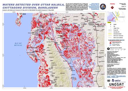
Image: UNOSAT satellite based assessment of impact of Storm Mahasen over Bangladesh. The full map can be downloaded at this link.