

OCHA and UNOSAT collaborate to monitor the humanitarian consequences of the battle for Mosul
03 August, Geneva, Switzerland — The fight against the Islamic State of Iraq and the Levant (ISIL) reached a turning point on 9 July when the Iraqi government declared victory in Mosul. Before this, between October 2016 and June 2017, Iraqi Security Forces and their supporters gradually retook the city, widely regarded as the “cultural center” of the Islamic State. By the beginning of June, ISIL members had retreated to its densest part, the Old City. At the time, an estimated 100,000 civilians were still living in this area full of narrow streets and alleys. People were desperate to escape but feared doing so as snipers targeted civilians that came into view. Others were used as human shields. An unknown number of civilians died in the attempt but almost one million people managed to flee to safety since October 2016.
Mosul’s Old City was once a charming vibrant area with myriad homes, shops and small alleyways. When fighting intensified inside the Old City, the monitoring of damaged buildings and satellite imagery provided by UNOSAT became a key tool in assisting humanitarian partners determine the most likely escape routes for civilians. The availability of this imagery informs humanitarian organizations such as the UN Office for the Coordination of Humanitarian Affairs (UNOCHA) in Iraq, enabling them to strategize and plan for the humanitarian response as people flee the conflict.
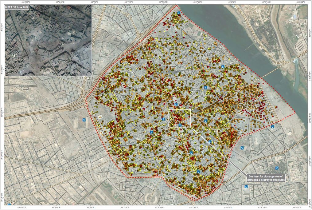
Three maps resulting from the collaboration between UNOSAT and UNOCHA were published on 6 July 2017 (see related links below). They show a serious increase in damage in the area over a two-week period. Using satellite images, UNOSAT could determine that a total of 5,536 structures were affected on 30 June, marking an overall increase of 113 per cent from a previous assessment on 11 June. Most of the damage was either moderate or severe, with less than 10 per cent of the affected buildings totally destroyed.
“We were able to ascertain the routes that people were taking when fleeing once we saw the satellite imagery,” said Themba Linden, OCHA’s Civil-Military Coordinator. “We passed on this information to humanitarian responders who set up mobile primary health clinics along the exit routes and distribution points for food, water and non-food items. People fled for their lives without any belongings and some children were malnourished, so the UNOSAT service was in fact life-saving for many civilians.”
The case of Mosul shows the real benefit of satellite imagery analysis in humanitarian situations. During periods of intense conflict, it is difficult to obtain accurate and reliable information on what is happening on the ground. Although the imagery may only give access to certain types of data, satellite images are extremely valuable when it comes to document what is happening behind the frontlines.
UN organizations and NGOs have made use of this imagery for a long time now. Many have already worked with UNOSAT on human rights and humanitarian issues. For instance, in the very same context UNESCO asked for an analysis of the damage to the 800 year-old Great Mosque of al-Nuri in Mosul, which was almost completely destroyed.
Satellite imagery and geoinformation are powerful tools that allow us to improve people’s lives in many ways. Enabling response teams to target some of the most vulnerable people escaping situations of conflict is just one way UNOSAT is contributing to the humanitarian response.
Related Links:
Mosul Damage Assessment (30 June 2017)
Mosul Damage Assessment (16 June 2017)
Mosul Damage Assessment (11 June 2017)
Image: Damage assessment in the Old City of Mosul as of 30 June 2017 (UNOSAT)