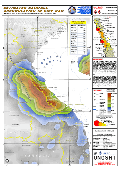
Several provinces in central Vietnam are being affected by torrential rains with an average rainfall of 300 to 800 mm according to reports received from UNDP Country Office. On 07 October UNOSAT humanitarian rapid mapping service was activated at the request of the UN country office in Vietnam to provide accurate geographic information on the extent of the flooding and its impact.
On the same day UNOSAT requested the support of the International Charter Space and Major Disasters, an international mechanism established by Space Agencies from several countries to help humanitarian mapping support by releasing satellite data on demand.
Hours after the activation UNOSAT released a first map highlighting the extent and intensity of rainfall on affected provinces. More maps will be released as satellite data is received and elaborated by the UNOSAT computing centre in Geneva. Geoinformation products can be seen and downloaded from UNOSAT website.
First news from the field indicate that some 61,000 houses have been flooded in 228 communities while over 14,000 households had been evacuated by 6 October. The situation is being aggravated by the formation of a tropical depression currently located west of Hainan Island (China), which is bringing more rain to central and north-central provinces.