

UNOSAT has long embraced public engagement to improve satellite applications and mapping technology. Already in 2006, UNOSAT, CERN and the University of Geneva joined hands to explore the potential of participatory mapping using CERN’s experiences on collaborative computing and collaborative thinking in particle physics. In July 2006 the first crowdsourcing experiment goes public. Building on these efforts the three partners joined by Berkley University and other scientific and technology partners and sponsors created the Citizen Cyberscience Centre (CCC).
With expanding experience in participatory mapping and other collaborative methods of data collection, UNOSAT has been a natural early adopter of crowdsourcing especially as part of its humanitarian rapid mapping service, created in 2003. The benefits of collaborative mapping have become more evident in recent years. UNOSAT enjoyed these benefits especially in response operations in Myanmar, West Africa, Pakistan, and Sudan. Based on these positive experiences UNOSAT is working at boosting its connection with crowdsourcing activities via innovative partnerships with a focus on applying the latest technologies.
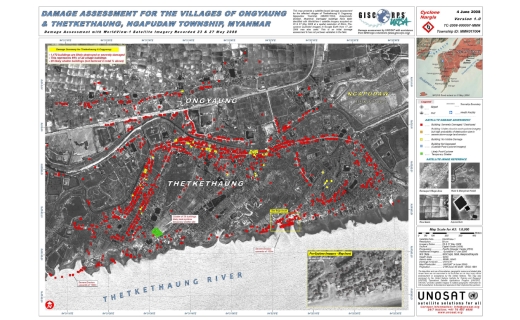
When Cyclone Nargis devastated Myanmar in May of 2008, UNOSAT engaged dozens of volunteers provided by GISCorps to undertake distributed mapping and damage assessment using very high-resolution satellite imagery shared via Google Earth. This effort involved several groups of GISCorps volunteers distributed around the world who together reviewed imagery of thousands of square kilometres of land for signs of destruction. This effort digitized 6,500 features within a week, providing valuable data products for both relief and reconstruction as well as crucial lessons for future crowdsourcing efforts.
Another critical effort in this regard was the mapping of flood extents in Western Africa in September 2009 at the request of the UN Office for the Coordinator for Humanitarian Affairs (OCHA). In this case UNOSAT benefitted directly from readily available and locally produced geospatial data on neighbourhoods, locales, and transportation networks that were produced by “crowd” volunteers using "Google MapMaker". This experience marked a turning point in merging basic data coming from volunteers into expert analytical maps because highly detailed and extremely accurate data on local features was available almost instantly at no cost. This type of data is perhaps the most valuable contribution of the crowd to mapping and analysis for disaster response and damage assessment using satellite imagery because it means less time spent by analysts in preparing base maps thus allowing faster production and more time for robust analytical work.
The devastating 2010 earthquake in Haiti resulted in an outpouring of relief and an unprecedented variety of crowdsourcing efforts. UNOSAT was heavily involved in damage assessment and analysis activities, ingesting data from the crowd but also synthesizing lessons learned from previous emergencies. The work was conducted in integrated and participatory involving the European Commission Joint Research Centre and the World Bank-GFDRR, the Haitian National Centre for Geo-Spatial Information, Swisstopo and the University of Zurich. This widespread effort combined imagery analysis conducted by specialists with widespread mapping and other information from the crowd. Combining pre-earthquake building information available from satellite imagery, place names and road vectors from Google Map Maker, additional road vectors from Open Street Map, and other data, UNOSAT and partner organizations were able to produce a comprehensive damage assessment atlas which is still informing Haitian reconstruction and engineering efforts today.
The evolution of crowd sourcing is mainly linked to the mapping of basic features such as place names and main features; yet the research being developed at UNOSAT and within the Citizen Cyberscience Center points at the possibility to develop sounder and more scientific approaches based on collaborative computing. These may represent the breeding ground for new crowd based and cloud-supported solutions for damage assessment and sophisticated thematic mapping.
Additional functionalities are being developed by the UNOSAT team with a number of partners. GEO-PICTURES is an example of how an Android app can be used to automatically geo-locate (tag) photos and resize them according to bandwidth to then send them off to a web-server. On the web-server, photo location is indicated on a map, and the photo can be further assessed, shared with individuals or groups and also uploaded in high resolution if needed. So far, this tool has successfully been used in Haiti, Pakistan and Nigeria.
In a similar area of interest UNOSAT and Hewlett Packard Labs are working on a test to apply crowdsourced geo-tagging of online information in territorial planning and land cover mapping as well as crisis situations. This experiment explores additional uses of the HP Gloe geo-tagging tool being experimented by HP Labs.