

Heavy rains in 2018 have triggered both flash floods and river floods in several parts of the country resulting in serious loss of life and widespread displacement of populations, In some provinces these floods are the worst since the early 20th century.
According to UN sources in the field, Khyber Pakhtunkhwa (KPK), Baluchistan, and Punjab have been the worst affected areas. Thousands of people have lost their homes and livelihoods. Crops have been destroyed, and roads and bridges damaged.
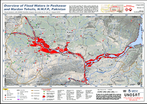
The UNOSAT Team, already activated on other current emergencies including floods in Moldova, was on stand-by over Pakistan in view of the monsoon season and was able to activated its rapid mapping service over the past weekend to begin acquiring satellite imagery to determine the extent of the flood in the most affected areas.
A first map was made available to the humanitarian community via the United Nations Office for the Coordination of Humnaitarian Affairs (OCHA) on Monday 2 August and a second on 3 August. UNOSAT was also called upon by the International Charter Space and Major Disasters to contribute mapping capacity to a combined effort to produce timely geographic information to help the government and international relief agencies with their work on the ground.