

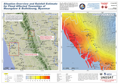
Flooding hit this month several remote villages of Northern Rakhine State (NRS) in western Myanmar. The situation required the activation of UNOSAT Humanitarian Rapid Mapping upon request by the UN Resident Coordinator in the country. According to UNDP reports, populations affected have received rice and other immediate relief items distributed by the UNDP's field offices in Buthidaung and Maungdaw townships. All relief efforts are done in collaboration with WFP, UNICEF and UNHCR, while UNOSAT was in charge to prepare geographic information products based on satellite imagery acquired prior to the event and after the event, thanks to the support received from the International Charter Space and Major Disasters. Thanks to combined UN efforts so far assistance has reached more than 1,030 affected households according to UNDP data.
UNOSAT has worked steadily in the last few years to refine its capability to map flooding events, which occur in many countries in Asia during the rainy season and require high interpretation skills to avoid analytical errors such as mistaking tidal waters for flood waters.
 One of the important advances realised by UNOSAT trough its partnership with Google allows the integration in the maps of data from Google’s MapMaker, which contributes to the internet information on geographical features on the ground directly from people familiar with the area. Again in the case of Myanmar emergency response, UNOSAT has canvassed this data into its work and on to UN and national beneficiaries in charge of responding to the dramatic situation in the villages affected by flood waters.
The maps being produced by UNOSAT with support from the Space Charter and Google are available also to the general public and specialists at the following link: MYANMAR FLOOD MAPS