

The recent floods in Vietnam have cause massive destructions and provoked a humanitarian situation in extensive areas in the country. The Province of Quang Tri has been particularly affected. The UNOSAT team has already posted on 1 October a first satellite derived map of flood affected areas which is used by national authorities and international relief entities to organize and coordinate relief efforts.
As always in case of humanitarian mapping, UNOSAT makes its maps available to the general public as well. The map is available for download here, as well as on GDACS and ReliefWeb.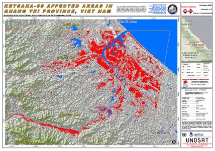
Users can also subscribe to RSS feeds for the latest UNOSAT maps for automatic updates when new maps become available here.
Comments and feedbacks on UNOSAT maps are most welcome.