

In an effort to complement the analysis of very-high resolution imagery with data acquired in the field and in-situ mapping, UNOSAT and French NGO ACTED (Agence de Cooperation Technique et Developpement) have established a specific collaboration agreement for the generation of advanced geographic information during and immediately after the crisis. The agreement, which comes after the two organisations started working separately but in consultation over the main areas affected by the incidents of the recent weeks, identifies a few specific areas of cooperation and the relevant output.
 F. Pisano, Manager of UNOSAT, said “UNOSAT and ACTED share an identical commitment for action oriented work and no-non sense operational procedures. We knew ACTED was a significant presence in the country and one equipped with professional GIS experts. From that , it was easy to determine the practical synergies and the optimal division of labour. ACTED was also producing some maps for UNHCR and we agreed to help them do so since HCR is one important sister agency for UNOSAT”.
The agreement provides for the sharing by UNOSAT of its analytical work to ACTED for verification in the field, internal use, and inclusion in ACTED mapping tools. In addition, UNOSAT and ACTED have produced a number of joint products by combining their respective data and analyses. These were realised directly in the country with technical backstopping from Geneva, using a well tested procedure that proves successful in situations of this kind. A ACTED official referring to the joint operation said “one of the best crisis mapping operations so far”
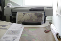
Photos: (1) ACTED and UNOSAT maps are printed in Kyrgyzstan for use in operations in the areas affected. (2) GIS experts work in a ACTED office in Kyrgyzstan. Each product is carefully validated before being used for operational work. Credit: ACTED 2010 / Antoine Vincent
Photo: ACTED 2010 / Antoine Vincent