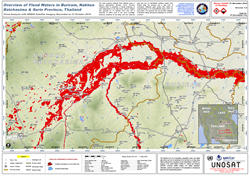
 According to Thai official sources last week, the death toll from flooding in Thailand stands at little less than 200 people. Thailand's Disaster, Prevention and Mitigation Department begun the count on October 10 when heavy rains caused rivers to overflow in several regions in the country, and many residents fled flooded areas for higher ground.
Reuters reported earlier this month that rescue teams evacuated stranded villagers by boat in some provinces, including the old Thai capital Ayutthaya where flood waters swelled to about 1.5 metres (5 ft) in some districts, cutting off roads and inundating homes, shops and farmlands.
These floods were the worst in decades according to Thai authorities. The excessive bad whether coincided also with a typhoon that headed for southern China after wreaking havoc across the northern Philippines and destroying thousands of homes.
The Geo-Informatics and Space Development Agency of Thailand (GISTDA) requested the support of the International Space Charter. UNOSAT was then requested to coordinate this particular Charter Call as Project Manager. A series of rapid crisis and impact assessment maps were produced by UNOSAT analysits coordinated by the Project Manager, Wendi Pedersen of UNOSAT.
These maps are available for public download on the Space Charter website and via www.unitar.org/unosat

