

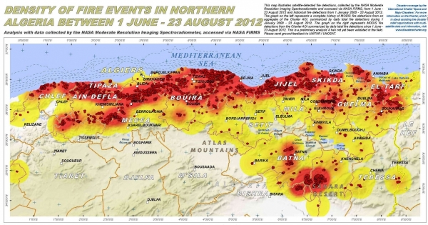
September 2012, Geneva, Switzerland - During the period June-August 2012, numerous wildfires burned throughout pine and cork oak forests in northern Algeria, scorching more than 30,000 hectares across Algeria, destroying both forest and bush. The flames also burned houses in several provinces, especially in the east.
The Algerian Civil Protection service mobilised 15,000 fire fighters to suppress fires. According to the Algerian press fires in such a size had not been seen since Independence.
UNOSAT was called to produce geospatial analysis of the extent and location of the wildfires. The International Charter Space and Major Disasters was also mobilised and contributed the satellite data on which UNOSAT experts have worked to generated the needed information.
You can view the Algeria wildfires maps in the UNOSAT website. The maps produced by UNOSAT have been posted also by the Space Charter itself and by UN-SPIDER.
Image: a detail of a UNOSAT fires density map capturing the evolution of the fires from June to August 2012.