

UNOSAT Rapid Mapping Confirms Heavy Damage in Vanuatu
Geneva, Switzerland, 16 March 2015 - Amid discussions of disaster prevention going on at the World Conference on Disaster Risk Reduction in Sendai, Japan, UNOSAT was scrambled by OCHA on 15 March in the immediate aftermath of colossal cyclone Pam, which hit the Vanuatu islands in the early hours of 14 March 2015. Within the same day of activation, UNOSAT requested the triggering of the International Charter Space and Major Disasters thanks to which the first imagery was received within hours during the same day.
The first satellite analysis by UNOSAT was made public on 16 March and corroborates reports trickling from Vanuatu regarding the heavy damage caused by the cyclone. The cyclone’s eye passed close to Efate Island, where the capital is located, and winds are estimated to have reached 250 kmph with gusts peaking at around 320 kmph, according to information circulating in the humanitarian circles.
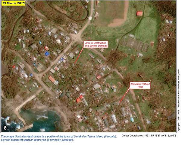
UNOSAT used high-resolution imagery collected by French Pleiades satellites on 15 March 2015 to identify areas with possible damage in locations that are remote. This type of mapping is useful to complement scattered information in the early stages of the crisis, especially over islands away from the capital. For example UNOSAT was able to assess the West Coast of Tanna Island, where according to satellite analysis approximately 1,200 buildings were severely damaged. UNOSAT is continuing to its imagery analysis which reveals that “in many areas there are heavy concentrations of damage”. Einar Bjorgo, who manages the UNOSAT Team, says: “this is a preliminary analysis and has not yet been validated in the field but it is very useful until all affected areas are reached by rescue and assessment teams. After the peak of the crisis we will start supporting the assessment and recovery work, working closely with UNDP”.
Related link
View all UNOSAT maps on Vanuatu at this link: http://www.unitar.org/unosat/maps/113