

May 2011, Geneva, Switzerland - The authorities of some of the Colombian departments affected by recent floods reported that this year’s flooding is worse than last year’s, with a death toll likely to rise above 500 while as many are still unaccounted for. Last year more than 2 million Colombians were affected by the floods according to figures released by OCHA.
UNOSAT responded to calls by the UN Office for the Coordination of Humanitarian Affairs requesting satellite analysis to determine the extent of the flood. In this case UNOSAT also requested the triggering of the International Space Charter on 21 May.
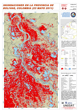
Already last week UNOSAT released a first map of floods in the Bolivar province. The map was produced by processing data received from the International Space Charter.
UNOSAT has been responding to this type of requests since 2003 with an average of 30 events per year. During this time, the contribution of the Space Charter has been substantial and many emergency response operations would have been much more complicated without the support of this mechanism.
The UNOSAT Team is committed to more than responding to requests for rush geospatial analysis, it strives to innovate and facilitate access to this type of data and information for the benefit of multiple international and national users.
While responding to the Colombian floods, UNOSAT launched a new enhanced way to disseminate information and data. Beside the map published by UNITAR/UNOSAT and the Charter web site, mapping entities directly involved in the humanitarian assistance for this event can retrieve satellite image derived flood extent vector files directly from UNOSAT Web Map Service (note that these links are visible only using appropriate GIS software).
UNOSAT is gradually integrating collaborative mapping and crowd sourcing into its work. In the case of the floods in Colombia, UNOSAT is reaching out to disaster managers and field staff in the country to assist with validation of the flood extent analysis and by sending in geographic position tagged photos. The application being used for this operation has been developed within the EU funded GEO-PICTURES project in which UNOSAT works with AnusR Technologies of Norway and numerous other partners.