

 As the situation in Pakistan continues to be a main concern due to new rainfall, UNOSAT analysts have completed on Thursday this week a series of maps derived from satellite imagery and aimed at identifying flood extent and impact on the affected populations in the Republic of Moldova.
UNOSAT had been working on Moldova since mid July when heavy rains and storms at the end of July caused floods in northern Moldova. Thousands of people have been evacuated while houses, bridges and roads have been damaged. In addition, people have been left without safe drinking water because of the flooded wells according to the Red Cross of Moldova.
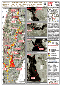
UNOSAT has published 5 maps in total, some including detailed geospatial analysis using FORMOSAT satellite data. The latest map, published on 5 August, shows probable standing flood waters along the eastern bank of the Prut River in the Cantemir District of the Republic of Moldova as well as the western bank of the river in Romania.
Two FORMOSAT images with 2 meter resolution were used to generate a flood water classification to cover the main areas of interest: Cahul and Cantemir. The analysis revealed that the most affected infrastructure, apart from Nisporeni, is the railway south of Cantemir. Michael Jendrike of UNOSAT who worked on the analysis said : “We used remote sensing and GIS software to threshold the panchromatic and near-infrared band information for water extraction. Flooding appears to be stable within the river embankment with small to medium damages in several villages along the river”.
The full series of UNOSAT maps on this event can be viewed and downloaded here.