

On 18 October 2012 UNOSAT was called to brief NGOs and UN staff in New York during an event organised by the UN Department of Public Information (DPI/NGO) at the UN headquarters. During the event, entitled “Crisis Mapping: How Satellite Imagery Analysis Can Benefit NGO Humanitarian Efforts”, a UNOSAT illustrated the type of support it provides to the humanitarian community and how NGOs in particular can benefit from geospatial technology. During the briefing, participants were encourage to tap into the wealth of knowledge developed by UNITAR in various other areas of research and innovative training in the fields of Environment, Peace, Security and Diplomacy, and Governance.
 Maria-Luisa Chavez, Chief of NGO Relations at UN/DPI, moderated a panel of three experts, including Dr. Scott Madry, Associate Professor at University of North Carolina at Chapel Hill, and Sara Farmer, Chief Technical Officer atChange Assembly. UNOSAT was represented by Jihad Abdalla, Emergency Officer at UNICEF. Mr Abdalla works at UNICEF’s Operation Centre where he is often in contact with UNOSAT analysts in Geneva during emergency operations.
In his presentation Mr Abdalla highlighted UNOSAT’s achievements and contributions to humanitarian action with examples from the Haiti crisis, the floods in Pakistan and the tsunamis in 2004 and 2011. He insisted on the importance of learning from past crises to enhance response to current and future emergencies. In his words: “one of the core functions of UNOSAT is to make sure satellite solutions and geographic information can be easily used by the UN family, NGOs and others who respond to crises and champion the work of reducing the impact of disasters and help nations plan for sustainable development”. He continued by saying: “partnership is everything and information is even more important than aid during emergencies to motivate NGOs members to directly engage with UNOSAT on crisis mapping”.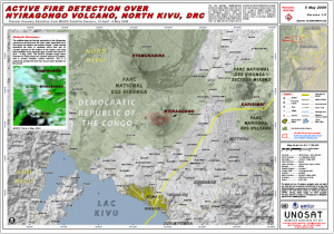 “We chose to present our work through the experience of one of our users instead of one of our own experts, to give a better impression of the difference we make each day with our work” says Einar Bjorgo of UNOSAT. UNOSAT started its Humanitarian Rapid Mapping Service in 2003. The service has been open to humanitarian NGOs since the very beginning in recognition of the important role of NGOs within the humanitarian community, where the United Nations, non-governmental organisations and national actors strive together against the impact of disasters and crises.
 In some instances NGOs have been more open to technology and innovation than other players in the humanitarian sphere, and more flexible in implementing change. It is the case of REACH, an initiative of UNOSAT, Impact Initiatives and ACTED, designed to provide a web-based mapping solution for rapid assessment after disasters and during crises. The system was developed in 2010 by the three partners and has been used in various crises with success, including in Libya. “When we presented this solution to the UN agencies in Geneva, Francesco Pisano recalls, everyone was pleased but also surprised that the system had been done together with NGOs and was already functional at no direct cost for the UN. I think we all recognized then that it would have taken years to arrive to the same results otherwise”.
As Jihad Abdalla said in New York “satellite technology has helped us to transform information into knowledge and our challenge in future will be to use this technology to reduce vulnerability”. Participants were impressed that UNOSAT had been developing integrated applications involving citizens as source of data and information and flying light UAVs to acquire optical data in the wake of disasters, like in the case of Haiti.
Ms Maria-Luisa Chavez, who moderated the discussion, said that the presentation left a “lasting impression” on NGO participants and that there were “many important take away messages for NGOs”.
Photos:
TOP: Jihad Abdalla (right) with Ms Chavez and Dr Madry at the event in New York (courtesy of UNDPI).
MIDDLE: An example of UNOSAT crisis mapping.
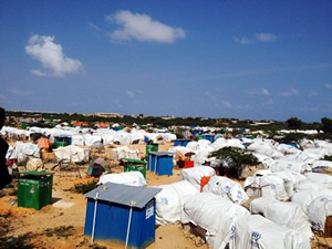
BOTTOM: One of the Somali IDP camps assessed by REACH (image courtesy of ACTED).